Silvertown Tunnel
- About the Silvertown Tunnel
- Why a new tunnel
- What benefits it will bring
- How we did it
- Tunnel user charges
- Concessions, discounts and exemptions
- Free zero-emission bus routes 108, 129 and Superloop SL4
- Silvertown Tunnel cycle shuttle
- After tunnel opening
- Highways
To deliver these benefits, charges now apply to both the Silvertown and Blackwall Tunnels. Without the charges, traffic would increase in both tunnels causing delays and congestion, which contribute to poorer air quality.
The user charge is designed to manage levels of traffic using the tunnels. It will also pay for the construction and ongoing maintenance and operation of the scheme. A package of concessions, discounts and exemptions is available to support Londoners, small businesses and charities. Visit our discounts and exemptions page for more information.
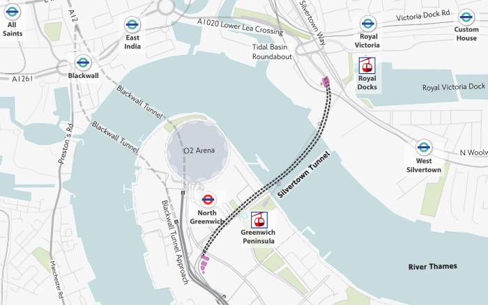
About the Silvertown Tunnel
This new 1.4km road tunnel, with 2 lanes in each direction and dedicated bus lanes, was first proposed in 2012 and plans were approved by the Secretary of State for Transport in 2018.
Construction has taken just under 5 years to complete. We're proud to bring into use this new infrastructure that will support residents and the local economy for many years to come.
Our plans also included improvements for walking and cycling around the tunnel entrances - part of major regeneration on both sides of the river.
Why a new tunnel
The Victorian-era Blackwall Tunnel was never designed for the levels of traffic that now need to cross the river. Incidents with larger, unsuitable vehicles frequently cause delays and closures.
Idling traffic builds up, often leading to tailbacks of several miles in just a few minutes. This increases journey times, as drivers either queue in traffic or choose longer routes to avoid the tunnel. It also has a negative impact on air quality.
What benefits it will bring
The Silvertown Tunnel has been designed to have a direct positive impact on local residents and businesses.
When it opens, it will:
- Help reduce congestion, delays and queues making peak time journeys faster and more reliable, with journey savings expected to be up to 20 minutes. This is based on modelled data compared to a non-Silvertown scenario. Today, around one million hours are lost each year to queuing because of Blackwall Tunnel closures
- Offer more opportunities to cross the river by public transport with an initial network of 21 zero-emission (at the tailpipe) buses an hour in each direction at the busiest times (between 07:00 and 19:00 Monday to Friday) offering new routes and better access to more places, jobs and opportunities. The new bus network is now operational and, to boost use of these services and support local people on the three-cross-river bus routes, we're offering free pay as you go fares on buses for at least one year. In addition, cross-river journeys on the DLR from Greenwich or Cutty Sark - Island Gardens, and Woolwich Arsenal - King George V will be refunded for at least one year
- Open up access to new markets on both sides of the river for businesses. This will help reach clients and jobs more quickly and within a reliable journey time. It will also help drive job growth in east London. Small businesses and charities within the boroughs of Newham, Greenwich and Tower Hamlets may be eligible for tunnel user charge discounts for at least one year. More information on how to apply is available on our discounts and exemptions page
- Help manage the air quality impact of traffic congestion on some of London's most polluted roads (based on modelled data). We've been monitoring air quality and traffic for the past 3 years across 5 London boroughs. We'll continue to monitor for at least 3 years after the tunnel opens. This is to make sure the tunnel user charge levels are working and the project meets its objectives. All our baseline reports are on the Silvertown Tunnel Implementation Group page
- Improve the resilience of the road network by offering an alternative crossing when the Blackwall Tunnel is closed, which can be around 700 times a year
- Offer a new, cross-river cycle shuttle service only for cyclists. This service is now running and offers a safe and quick way for cyclists to cross the river using the Silvertown Tunnel. The service is a high-frequency point-to-point service running every 12 minutes. We're committed to it for at least 3 years and the service will be free for at least one year
How we did it
Riverlinx consortium won the bid to design, build, finance and maintain the Silvertown Tunnel after a competitive procurement process in 2019. The vast majority of the funding to build the new crossing was raised by the consortium through private finance. Now the tunnel is open, TfL will collect the tunnels user charge and repay the costs through regular availability payments linked to operational performance.
During the construction of the new tunnel, more than 1,860,000 tonnes of material were transported to and from the site via the river rather than using roads. That helped to remove around 110,000 lorry trips from local roads around the construction site.
The tunnel boring machine, Jill (named after Jill Viner, London's first female bus driver), was also innovatively turned around within the rotation chamber in Greenwich. Then, it bore the second tunnel back towards Newham - a UK engineering first.
More than 120 apprenticeships were created across the supply chain, and around 90 previously unemployed people were hired. The scheme also offered more than 1,500 placement days for the next generation of engineers.
-

1 of 2 Silvertown Tunnel Inside the Silvertown Tunnel

Tunnel user charges
Consultation
The tunnel charges exist to help manage traffic levels across both tunnels, repay costs for building the new Silvertown Tunnel and its ongoing maintenance and operation.
To consider the views of the public closer to the tunnel opening, we held an eight-week consultation from 10 July to 3 September 2024, receiving over 5,300 responses.
Consultation responses were analysed and recommendations made to the TfL Board on the user charge levels, discounts and exemptions. On 4 December 2024, the TfL Board confirmed the initial opening charges that will apply from 7 April 2025.
For full details of the Silvertown and Blackwall Tunnel user charges consultation, visit our Have Your Say page. This includes our consultation report setting out our findings and our responses to the issues raised.
How the charges work
From 7 April 2025, charges will apply to both the Blackwall Tunnel and the new Silvertown Tunnel. If you drive through either tunnel, you will need to pay each time you cross, unless you or your vehicle are exempt from paying the charge.
Charges will apply from 06.00-22.00, 7 days a week in both directions. The tunnel will be open 24 hours a day every day of the week.
Find out all about what and how to pay the Blackwall and Silvertown tunnels charge.
Concessions, discounts and exemptions
To support residents and businesses and encourage people to use the new public transport connections, there are concessions, discounts and exemptions available. These include:
- Bus concessions for local residents on the new Superloop SL4, the extended route 129 and route 108
- DLR concessions for local residents between Greenwich/Cutty Sark - Island Gardens and Woolwich Arsenal - King George V
- 50% discount on tunnel charges for residents on certain low-income benefits
- £1 discount on the off-peak charge for eligible small businesses, charities and sole traders
For more information on Bus and DLR concessions including the refund process, visit our new Silvertown Tunnel page.
To register for the tunnel's discounts, visit our discounts and exemptions page.
Free zero-emission bus routes 108, 129 and Superloop SL4
The Silvertown Tunnel will transform how residents in east and southeast London will be able to cross the river by bus for work, education and leisure. Up until today, only the 108 bus has been able to cross the river from North Greenwich via the Blackwall Tunnel. No double-deck buses were previously able to cross the river between Tower Bridge and the Dartford Crossing.
Now that the Silvertown Tunnel is open, in addition to route 108 (via the Blackwall Tunnel), a new route (Superloop SL4) running through the new tunnel from Grove Park to Canary Wharf. Also, route extension (route 129) is running from Lewisham to Great Eastern Quay via City Airport.
Pay as you go travel is free on these routes for at least 12 months after the tunnel opens. You must touch in with a valid Oyster card or contactless card or device, but the fare will be £0.00.
In total, the 3 routes will offer a new east London cross-river bus network of 21 zero-emission (at the tailpipe) in each direction in the busiest times between 07:00 to 19:00 Monday to Friday.
Visit our Silvertown Tunnel bus changes page for more information.
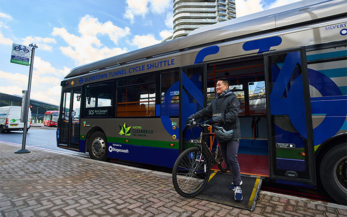
Silvertown Tunnel cycle shuttle
The new cycle shuttle service offers a safe and quick way for cyclists to cross the river using the Silvertown Tunnel.
Cycling is not allowed in the Silvertown Tunnel for safety reasons. Instead, we're providing a high-frequency shuttle service with a bus every 12 minutes (5 buses per hour). Cyclists can turn up and go without checking a timetable first.
Cyclists will board the bus with their cycles at stops on either side of the river to be taken through the Silvertown Tunnel. In Newham, the 'north' stop location is located on Seagull Lane close to Royal Victoria DLR station. In Greenwich, the 'south' stop is located on Millennium Way near the junction with Old School Close.
The service has a unique look to distinguish it from the regular bus network (see image below). For detailed guidance on how and when customers can use the service, visit our Silvertown Tunnel cycle shuttle page.
After tunnel opening
The Silvertown Tunnel opened on 7 April 2025 and is operating new bus services and the Silvertown Tunnel Cycle Shuttle as planned.
A user charge has now been introduced from 06:00 to 22:00, 7 days a week, to help manage traffic levels across the Silvertown and Blackwall tunnels, repay costs for building the new Silvertown Tunnel, and cover ongoing maintenance and operation costs at both tunnels.
Without introducing this user charge at both tunnels, there would be higher levels of traffic and congestion in the area. Which would lead to impacting air quality negatively, as well as longer journey times.
We'll continue to monitor and report on traffic, air quality, and the scheme's impact on residents and businesses. All our baseline reports are on the Silvertown Tunnel Implementation Group page.
Highways
A review and update to our traffic modelling work found 14 locations needing mitigations before the Silvertown Tunnel opened. This reflects any changes since the DCO was granted.
These mitigations were discussed and agreed with Silvertown Tunnel Implementation Group members, and then reviewed and approved by the Secretary of State for Transport. The works were to prepare local roads for the tunnel opening.
The traffic mitigation map shows 14 locations that needed mitigation measures installed before the Silvertown Tunnel opened. Among them were 11 locations that needed signal-timing optimisation and 3 that needed physical mitigation.
All physical mitigation works are now complete. The link under the flyover at Bow will remain closed until we complete more works to protect the structure later in 2025.
Now that the tunnel is open, signal timing changes are being made in real time and will be monitored closely in the first weeks of operation. These mitigations aim to proactively prevent adverse impacts on local communities.
We'll continue to monitor the impacts on highways and air quality for at least 3 years and will consider more mitigation work if needed. Read about our monitoring work on the Understanding the impacts of Silvertown Tunnel page.
Related content
- Learn the impacts of Silvertown Tunnel on local communities both before and after the tunnel opened
- Read about the Silvertown Tunnel Implementation Group (STIG) that includes representatives from 12 London boroughs, the GLA and National Highways
- Check our large archive of the Silvertown Tunnel documents related to previous consultations, planning conditions, general vesting declarations and our Development Consent Order
Contact us
For tunnels charge enquiries
