Crossrail 2
Request ID: FOI-2915-1819
Date published: 17 May 2019
You asked
TfL issued a statement (copy enclosed) to the Planning Inspectorate on the 10th November 2017 in support of their letter of objection to a planning application for No 2 Merton Hall Road SW19.
In the statement TfL claimed, that as a consequence of Crossrail 2, there was a need a to widen the South West Main Line from 4 to 6 tracks, in addition to the 2 required for the existing Thames link service. TfL also claimed that as a result of further research/engineering it would now need to safeguard more land to the top of Merton Hall Road to accommodate Crossrail 2. TfL also enclosed a map with the statement.
On the 24th March 2015, the Secretary of State issued a Safeguarding Direction in relation to the Cross rail 2 route (copy enclosed). The supplementary notes state:
“
6. The land within the Directions comprise:
(a) Land designated on the plans as “Areas of Surface Interest” being the surface sections of the proposed line, additional land that may be required permanently or
temporarily for works such as drainage, road diversions and environmental protection measures, construction sites, spoil disposal sites, ventilation shafts, intervention and escape shafts and land above tunnels in the vicinity of tunnel portals and stations; and”
This means that all the land necessary for the delivery of Crossrail 2 has been allowed for within this direction at that point in time.
I would like a copy of the map/schematic that shows the 6 SWML tracks, plus 2 Thameslink tracks, as they fit within the 2015 safeguarding map, on the 24th March 2015, at the pinch point between Merton Hall Road and Elm Grove SW19.
I would like a copy of the same map after the revisions have been applied and the date that they were applied.
Given that the 2015 Safeguarding Directions, state that all land necessary for the delivery of Crossrail 2 has been allowed for, I would like a detailed explanation for the difference between the two.
We answered
Our Ref: FOI-2915-1819
Thank you for your request received on 30 January 2019 asking for information about Crossrail2.
Your request has been considered in accordance with the requirements of the Freedom of Information Act and our information access policy. I can confirm we do hold the information you require. You asked:
I would like a copy of the map/schematic that shows the 6 SWML tracks, plus 2 Thameslink tracks, as they fit within the 2015 safeguarding map, on the 24th March 2015, at the pinch point between Merton Hall Road and Elm Grove SW19.
Please find the attached map which was produced in 2014 and shows the South West Main Line and Thameslink tracking as it fits within the 2015 Safeguarding Directions. This map reflects our thinking for the scheme in 2014. This informed the 2015 Safeguarding Directions and the subsequent 2015 route-wide consultation proposals. It assumed a certain station configuration at Wimbledon, which informed the proposals in the 2015 route-wide consultation.
I would like a copy of the same map after the revisions have been applied and the date that they were applied.
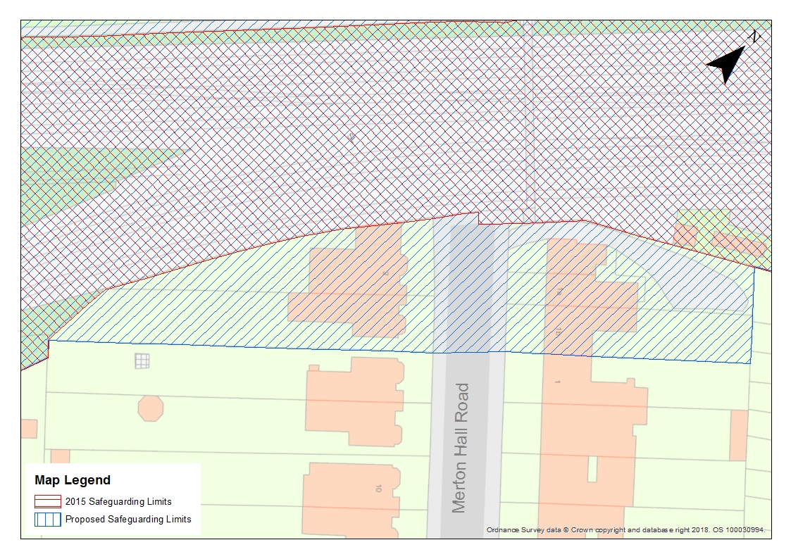
A map showing our proposed revisions to the 2015 Safeguarding Directions, and how this would impact 2 Merton Hall Road was issued to you in December 2018 in response to FOI-031-1819 / IRV-011-1819 / FER0755263. Please find a copy attached for ease of reference. This map shows the tracking and the additional land we would wish to safeguard as part of an updated or new Safeguarding Direction.
Given that the 2015 Safeguarding Directions, state that all land necessary for the delivery of Crossrail 2 has been allowed for, I would like a detailed explanation for the difference between the two.
The reason that we would need this extra land at Merton Hall Road is to enable us to build the extra tracks and dive-under beneath the South West Mainline and Thameslink tracks, as previously proposed, but reflecting the feedback received during the route-wide public consultation in Autumn 2015. This feedback required the Crossrail 2 project team to re-visit the scheme design for Wimbledon station, including a reassessment of the land needed between Wimbledon and Lower Downs Road. As a result of this technical work, we have proposed to include 2 Merton Hall Road within any future updated safeguarding directions. This will enable us to construct the railway while keeping the impact to the operational South West Mainline and Thameslink services to a minimum.
If this is not the information you are looking for, or if you are unable to access it for some reason, please feel free to contact me.
Please see the attached information sheet for details of your right to appeal.
Yours sincerely
Gemma Jacob
Senior FOI Case Officer
FOI Case Management Team
General Counsel
Transport for London
[email protected]
Attachments
Back to top